| http://stratochem.com/?attachment_id=371 |
Thursday, April 10, 2014
53. Star plots
52. Correlation matrix
| http://www.emeraldinsight.com/journals.htm?articleid=1515237 |
51. Similarity matrix
| http://tomcat.esat.kuleuven.be/txtgate/tutorial.jsp |
50. Stem and leaf plot
| http://mainland.cctt.org/mathsummer/josephbond/stemandplots/stem-and-leaf_std.htm |
49. Box plot
 |
| http://rtutorialseries.blogspot.com/2010/02/r-tutorial-series-regression-with.html |
Wednesday, April 9, 2014
48. Histogram
| http://www.ct4me.net/Ohio_Graduation_Math_Test_Prep_DataStrand.htm |
47. Parallel coordinate graph
| http://vis.lbl.gov/Vignettes/Drosophila/index.html |
46. Triangular plot
| http://www.ex-parrot.com/~chris/wwwitter/20050407-it_doesnt_matter_how_you_vote_either_way_your_planet_is_doomed.html |
45. Windrose
| http://www.nc-climate.ncsu.edu/windrose.php |
44. Climograph
| http://www.colorado.edu/geography/extra/geogweb/bouldercreek-2/preview/page2.html |
43. Population profile
| http://www.census.gov/2010census/ |
42. Scatterplot
| http://www.stat.yale.edu/Courses/1997-98/101/scatter.htm |
41. Index value plot
| http://waterwatch.usgs.gov/new/?m=real&w=plot&r=nm |
40. Accumulative line graph or Lorenz curve
| http://worthwhile.typepad.com/worthwhile_canadian_initi/2011/09/why-are-we-still-using-the-gini.html |
39. Bilateral graph
| http://commerce.nic.in/publications/anualreport_chapter9.asp |
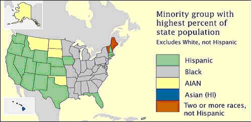
38. Nominal area choropleth map
 |
| https://courseware.e-education.psu.edu/courses/geog482/policies.shtml |
37. Unstandardized choropleth maps
| http://eps.mq.edu.au/courses/GEOS219/choropleth.htm |
Tuesday, April 8, 2014
36. Standardized choropleth maps
| http://www.statcan.gc.ca/pub/92f0138m/2008003/figures/5200001-eng.htm |
35. Univariate choropleth maps
 |
| http://www.clearlyandsimply.com/clearly_and_simply/2009/06/multicolored-choropleth-maps-with-excel.html |
34. Bivariate choropleth maps
| http://www.geo.unizh.ch/~annal/Choropleth%20maps.html |
33. Unclassed choropleth maps
| http://indiemapper.com/app/learnmore.php?l=choropleth |
32. Classed choropleth maps
| http://indiemapper.com/app/learnmore.php?l=choropleth |
31. Range graded proportional circle map
 |
| http://www.e-cartouche.ch/content_reg/cartouche/cartdesign/en/html/ThemMaps_ThemData.html |
30. Continuously variable proportional circle map
 |
| https://www.e-education.psu.edu/geog486/book/export/html/1796 |
29. DOQQ
 |
| https://www.lib.ncsu.edu/gis/doqq.html |
28. DEM
| http://www.weather.unisys.com/usgs/index.php |
27. DLG
| http://www.dnr.sc.gov/GIS/descdlg.html |
26. DRG
| http://egsc.usgs.gov/isb//pubs/factsheets/fs08801.html |
25. Isopleths
| http://geographyfieldwork.com/DataPresentationMappingTechniques.htm |
24. Isopach
| http://seeps.geol.ucsb.edu/pages/isopach.html |
Monday, April 7, 2014
23. Isohyets
| http://traveloutbackaustralia.com/start-here/outback-climate-and-weather.html |
22. Isotachs
| http://www.erh.noaa.gov/btv/events/28Oct2008/ua2.php |
21. Isobars
| http://www.nc-climate.ncsu.edu/edu/k12/.IsobarIsotherm |
20. LIDAR
| http://www.noaanews.noaa.gov/stories/s798.htm |
19. Doppler radar
| http://www.srh.noaa.gov/tae/?n=event-20090413 |
Saturday, April 5, 2014
18. Black & white aerial photo
| http://www.math.toronto.edu/drorbn/Gallery/KnottedObjects/Interchange/index.html |
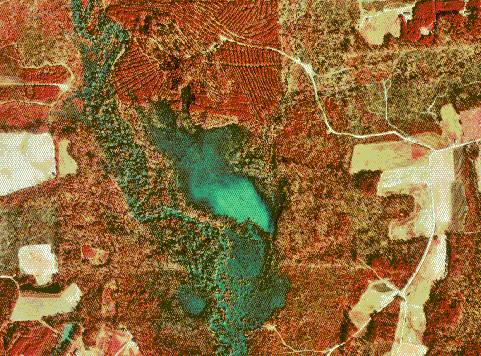
17. Infrared aerial photo
| http://www.outintheboonies.com/Arbuckle_Tract/ |
IR aerial photos are obtained by satellites, high altitude aircraft and are useful for looking at vegetation patterns, environmental pollution, effect of human activities and study land form. This is important because without this technology, we would not be able to see the Earth outside of its natural colors, because IR light is outside of our visible range. The wavelengths that infrared aerial film record gives scientists a better understanding of the Earth's surface, and contrasts land/water clearer.
Wednesday, April 2, 2014
16. Cartographic animations
 |
| http://rsd.gsfc.nasa.gov/rsd/images/andrew.html |
15. Statistical maps
| http://www.censusscope.org/us/map_unmarried.html |
14. Cartograms
| http://www.brainpickings.org/index.php/2010/04/15/cartograms/ |
13. Flow maps
| http://ops.fhwa.dot.gov/freight/freight_analysis/faf/faf2_reports/reports7/c5_assign.htm |
12. Isoline maps
| http://www.lib.utexas.edu/maps/atlas_mexico/ |
11. Proportional circle maps
| https://www.flickr.com/photos/89769525@N08/with/8242929652 |
10. Choropleth maps
| http://my.ilstu.edu/~jrcarter/Geo204/Choro/Tom/ |
9. Dot distribution map
| http://gothos.info/2013/03/the-geography-of-us-public-libraries/ |
Subscribe to:
Comments (Atom)